
I think it’s important for us as forecasters to look back and ask a simple question: How did we do?
Every forecast is an opportunity to learn. Whether we were right or wrong, there are lessons in the forecast process, and looking back helps us understand what worked, what didn’t, and why.
Let’s start with our preseason hurricane forecast.
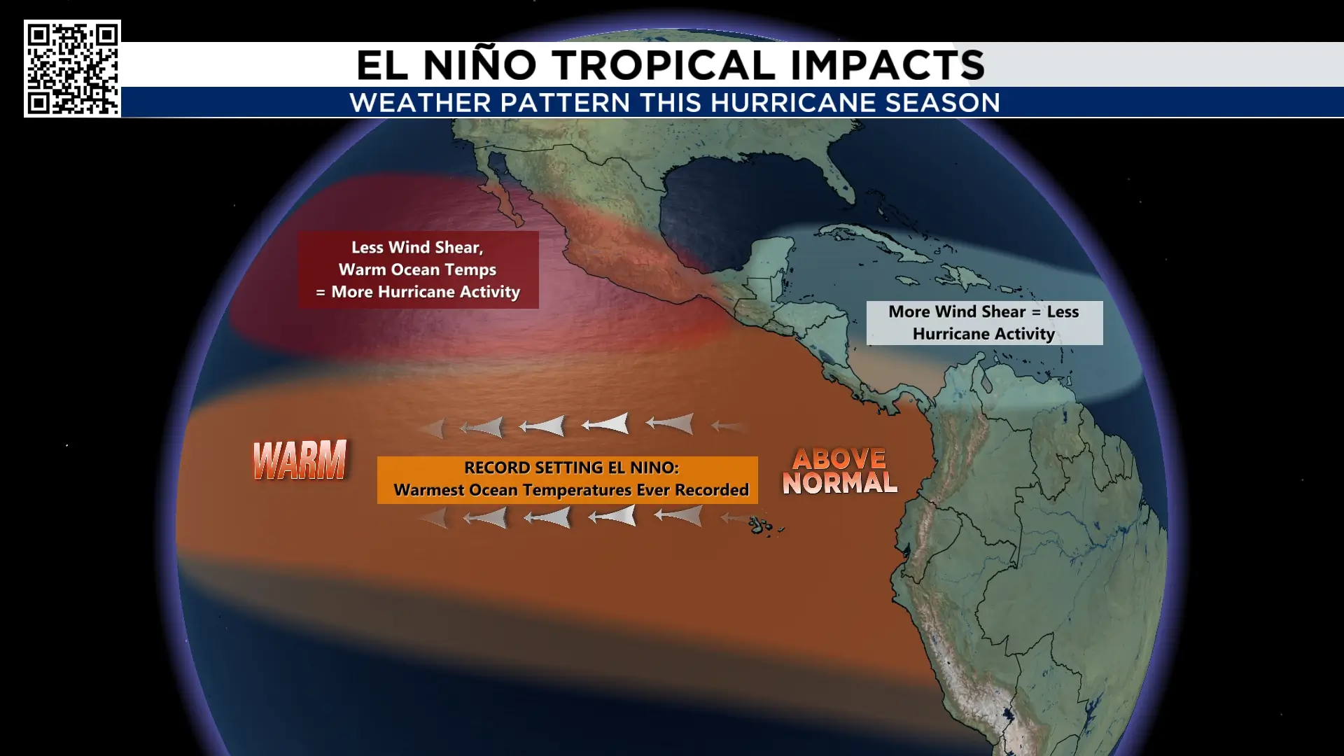
Before June, we talked about the potential for a quiet Atlantic hurricane season and a much more active season in the Pacific. We even singled out Hawaii as an area to watch for potential hurricane impacts.
The reason? An incredibly strong El Niño climate pattern was expected to create a more favorable environment for hurricanes in the Pacific, with warmer ocean temperatures and less wind shear. In the Atlantic, the opposite was expected. Stronger wind shear, winds changing in speed and direction with height, would make it more difficult for tropical systems to develop and strengthen, particularly in the Main Development Region.
So, now that we’re well into the season, it’s time to look back at that forecast and see how it compared with what actually happened.
If you’d like to revisit our preseason forecast, click here.
KPRC’S 2026 Hurricane & Flood Survival Guide | What You Need to Know Before the Next Storm
The preseason hurricane forecast:
Historically, strong El Niño years tend to favor a more active Pacific hurricane season and a less active Atlantic season. However, the Atlantic’s exceptionally warm ocean temperatures meant that any storms that did develop could still have the potential to become intense.
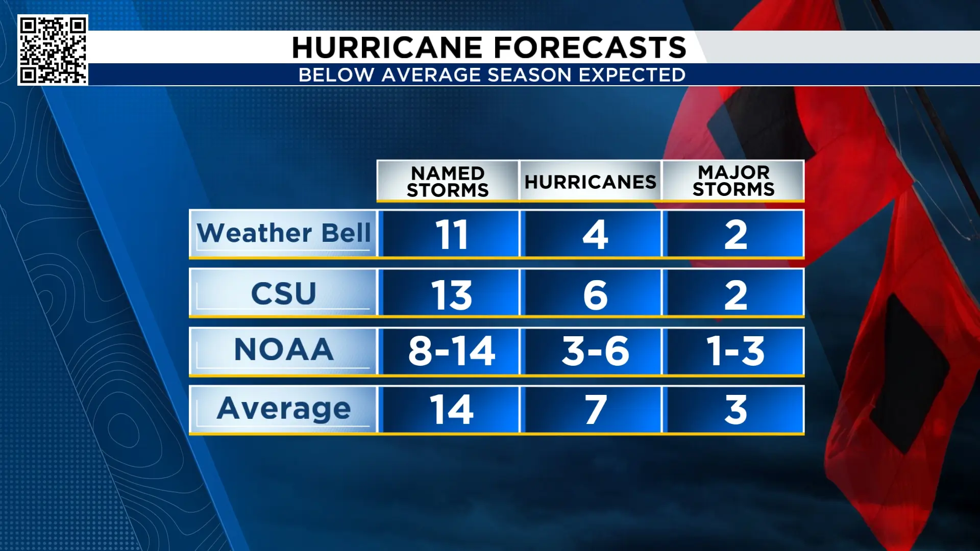
Here’s a look at the preseason forecasts from the major hurricane forecasting groups. As the season progressed, several of these forecasts were revised downward.
What’s happened through the heart of the hurricane season in the Pacific:
Let’s start with the Pacific Basin.
The Northeast Pacific is on pace for its most active hurricane season on record. One of the best ways to measure the overall strength of a hurricane season is Accumulated Cyclone Energy, or ACE. It accounts for both the strength and duration of tropical systems.
So far this season, ACE is approaching 250. The long-term average is around 100. That puts this season in rarefied air.
And it’s not just one statistic. The Pacific has been busy in several remarkable ways.
- More tropical activity has been recorded than in any previous season at this point.
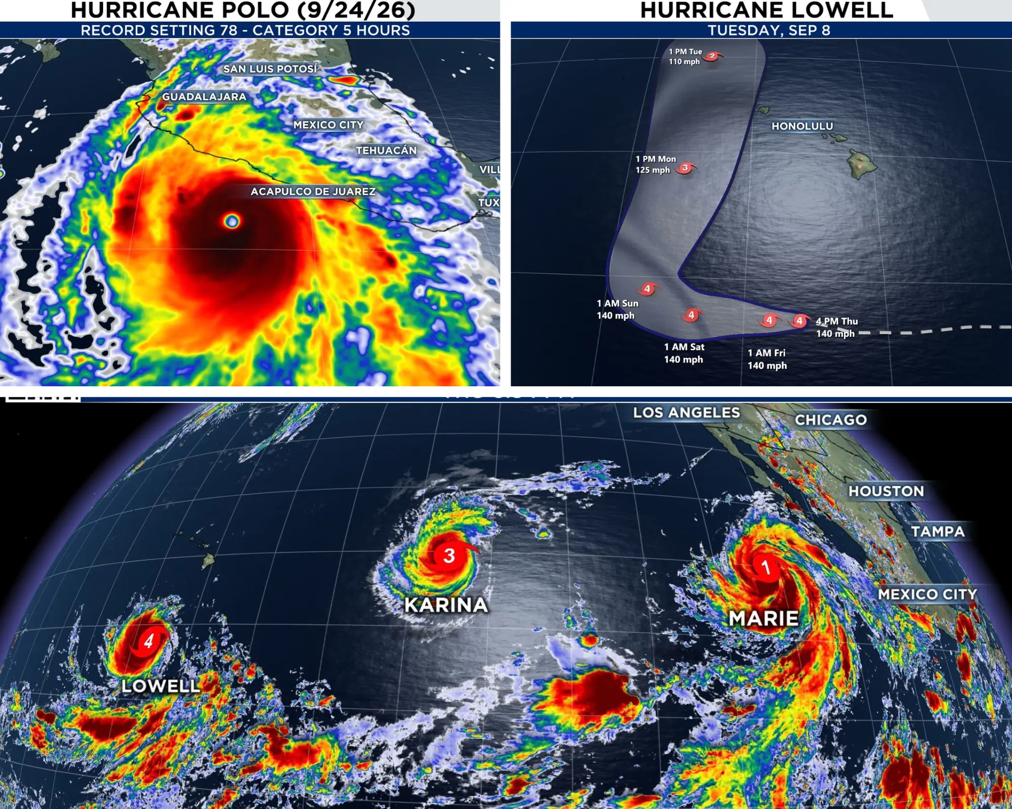
- Hawaii has experienced three hurricane impacts from Lala, Lowell and Nolo.
- In September, over a three-week period, the Pacific had three hurricanes occurring simultaneously, not once, but twice.
- Hurricane Polo became the second-strongest hurricane ever recorded in the Eastern Pacific based on minimum pressure. It also set a record for longevity as a Category 5 hurricane, remaining at Category 5 strength for 78 hours. The previous record was Hurricane John in 1994, at 60 hours.
Taken together, these numbers tell a pretty remarkable story: the Pacific is behaving much like we anticipated it might, and more, during an exceptionally strong El Niño.
A record setting Atlantic hurricane season in the opposite direction:
Now let’s turn to the Atlantic, where the story is the complete opposite.
Even though we expected a quieter-than-average hurricane season, what has happened so far is remarkable. As of September 28, the Atlantic’s Accumulated Cyclone Energy, or ACE, is near 10. The long-term average for this point in the season is roughly 10 times higher.
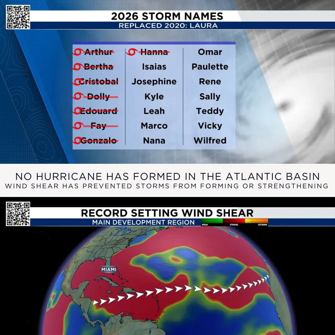
So far, there have been eight tropical storms and no hurricanes.
That puts 2026 in record territory. The previous record for the latest first hurricane was set in years when Gustav and Humberto formed on September 11. This means our 2026 hurricane season will set a record for the latest hurricane to form.
And it’s not just a lack of activity. The atmosphere is actively working against tropical development.
There is strong wind shear across the Main Development Region, and the shear has been record setting strong. Ocean temperatures in parts of the Caribbean are also running below average, while a more stable atmosphere is making it difficult for storms to form.
Put all of those ingredients together, and you have an Atlantic Basin that has been remarkably hostile to tropical development.
So, did our preseason forecast get it right?
Broadly, yes. We correctly anticipated a much more active Pacific and a quieter Atlantic. What we didn’t anticipate was just how extreme the difference would become in both basins.
What’s next?
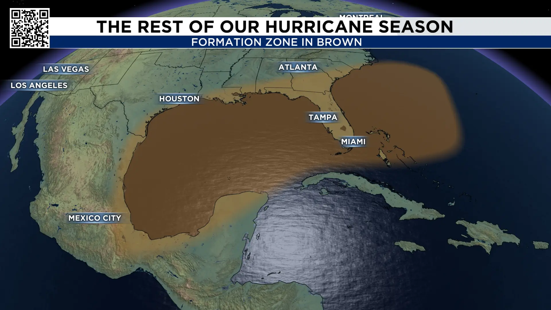
There is still one part of this hurricane season that has concerned me from the beginning: The Gulf.
Water temperatures in the Gulf remain record warm, and for much of the season, wind shear in the Gulf has been relatively weak, two ingredients that can support tropical development and intensification.
Three of the eight named storms this season have also affected Southeast Texas. Arthur, Bertha and Edouard each impacted our area in different ways.
One scenario we’ll continue to watch for is a front moving into the Gulf. Tropical systems can sometimes develop along these boundaries and then move inland. There is no indication that this will happen this week, but it’s something we’ll continue to keep an eye on for you.
Typically, once our first true cold front moves through Southeast Texas, the steering currents begin to change. That tends to make it more difficult for storms in the Gulf to move toward Texas and can instead steer them toward Mexico or Florida.
But hurricane season isn’t over just yet.
The latest a hurricane has ever made landfall near Galveston was October 16, when Hurricane Jerry came ashore in 1989.
So while the odds of a late-season Gulf hurricane decrease as we move deeper into fall, we’re not at the finish line yet.

More Stories Like This In Our Email Newsletter
