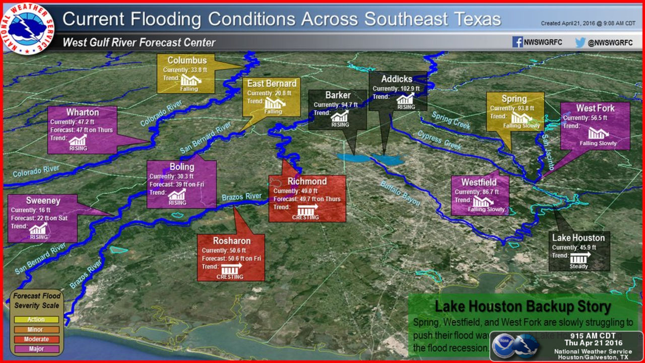
HOUSTON – Water from the Addicks and Barker reservoirs, the two west side dams that protect Houston from a flood of biblical proportions, is being released into Buffalo Bayou at a controlled rate.
The release of water at the Barker Reservoir dam into Buffalo Bayou began Thursday evening. The release will lower the water levels in the reservoirs.
"Those higher levels we feel comfortable the bayou can handle them without any major issues. It'll definitely stay within in the banks we do not anticipate any structural problems with homes or anything like that," Richard Long, U.S. Army Corps of Engineers, said.
The Harris County Flood Control District said the normal release rate will be doubled, causing water levels in Buffalo Bayou to rise between Highway 6 and downtown Houston. Post spotters will be placed along the bayou to ensure there is no trouble.
Long said Bear Creek Village may not see relief from encroaching reservoir water for another day or two, when Addicks Dam outflow exceeds inflow from area creeks.
Parks and areas along the bayous that will be affected are:
- From State Highway 6 to Piney Point Road the bayou may be up to 5 to 6 feet above normal release levels and some low-lying trails in Terry Hershey Park will have water on them.
- From Piney Point Road to Loop 610, the bayou may be up to 4 to 5 feet above normal release levels.
- From Loop 610 to downtown, the bayou may be up to 3 to 4 feet above normal release levels and there could be water in low-lying sections of Buffalo Bayou Park.
The releases will continue until the reservoirs are emptied.
Emergency management officials asked residents who live on streets adjacent to Addicks Reservoir Thursday to prepare for potential flooding conditions.
The areas most likely to see street flooding, and potential house flooding, are located on the perimeter of Addicks Reservoir in the Bear Creek Village subdivision just northeast of the State Highway 6/Clay Road intersection, and south of Addicks-Satsuma Road.
"These are both pools of record we have not seen this much water before. The dams are being tested for the first time with this much water," Richard Long, with the U.S. Army Corps of Engineers, said.
In 70 years, neither dam has ever looked like this, and in some neighborhoods, the reservoirs are slowly moving in, up and over Highway 6 for miles.
[LIST OF HIGH WATER LOCATIONS]
"Twenty-three years, never seen it like this before," said one resident.
(Map below: Bear Creek Village streets near the SH 6/Clay Road intersection at risk of flooding.)
Even with planned releases to lower both dam levels starting Thursday night, homes are in jeopardy as each dam spreads to its outer reaches.
The outer reaches are neighborhoods. Hundreds of houses are essentially not just near, but within the dams.
"The Cinco Ranch area and the Bear Creek area are actually within the maximum storage area of our projects," Long said. "We have filled up the government-owned land, but that doesn't mean the dam is at capacity."
That is a cold hard truth if you live in one of the neighborhoods.
(Map below: Bear Creek Village streets near Addicks-Satsuma Road at risk of flooding.)
Water levels may remain high for days or weeks, depending on additional rainfall and reservoir release rates.
Officials said the following streets in Bear Creek Village have the potential to fill with storm water and may be impassable in the next few days:
- Sandy Hill
- Pine Mountain
- Lost Spring
- Mill Hollow
- Sylvan Glen
- Hickory Grove
- Birch Vale
- Aspen Glen
- Bear Hill
- Regency Villa
- Pine Forest
- Fox Springs
- Pagehurst
- Fern Ridge
- Pinecliff
- Thornbrook
- Midridge
- Prairie Creek
- Four Season
CLICK HERE TO CHECK THE WATER LEVELS IN YOUR AREA

Local fire and police departments performed more than 1,800 rescues across Harris County and surrounding areas, emergency management officials said.
According to officials, this week's flooding is the worst in the area since Tropical Storm Allison hit in 2001.
Get weather in the palm of your hand with our FREE Frank's Forecast Weather app:
Apple --> http://bit.ly/1ae9au1
Android --> http://bit.ly/HqqNR6
Pin your pics on the FREE KPRC 2 StormPins app:
Apple --> http://bit.ly/1lD1KXL
Android --> http://bit.ly/Sbni6s
To see images sent in by by Click2Houston viewers on the KPRC 2 StormPins app, click here.
(function(d, s, id) {var js,ijs=d.getElementsByTagName(s)[0];if(d.getElementById(id))return;js=d.createElement(s);js.id=id;js.src="//embed.scribblelive.com/widgets/embed.js";ijs.parentNode.insertBefore(js, ijs);}(document, 'script', 'scrbbl-js'));